#disaster-go
2025-01-02
mrorz
14:46:36
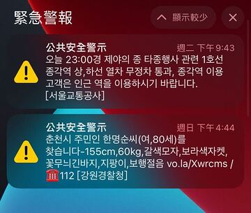
Replied to a thread: 2025-01-02 14:24:12
2025-01-03
chewei 哲瑋
08:15:36
Note: 日本的防災避難據點資料好像有多釋出一些欄位,待研究 & 筆記到 hackmd 共筆 way to safety
https://x.com/gisphn/status/1871712593234247696?s=46&t=buMJRdNMAf0Cwh2apny74w
https://x.com/gisphn/status/1871712593234247696?s=46&t=buMJRdNMAf0Cwh2apny74w
X (formerly Twitter)
指定避難所データが12/24に提供開始されてる! 指定緊急避難場所に加え、指定避難所の緯度経度を含み全国、都道府県、市区町村別にダウンロード可能。絞り込み検索や自治体ごとの更新日も記載とめっちゃ助かる! 国土地理院@GSI_chiriinサンタからのクリスマスプレゼント:blush: <https://t.co/UASYtJR1N3>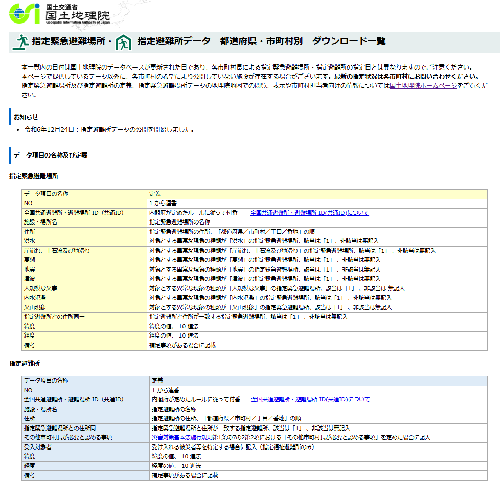
chewei 哲瑋
08:15:36
Note: 日本的防災避難據點資料好像有多釋出一些欄位,待研究 & 筆記到 hackmd 共筆 way to safety
https://x.com/gisphn/status/1871712593234247696?s=46&t=buMJRdNMAf0Cwh2apny74w
https://x.com/gisphn/status/1871712593234247696?s=46&t=buMJRdNMAf0Cwh2apny74w
2025-01-17
chewei 哲瑋
23:23:13
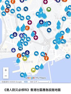
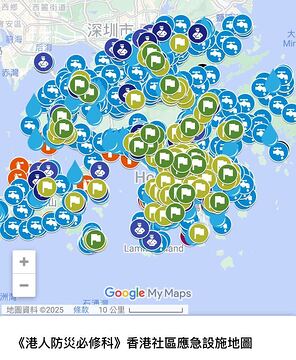
已在 waytosafety 共筆文件中 納入 香港社區應急設施地圖資料集
地圖:https://www.google.com/maps/d/u/0/viewer?usp=sharing&mid=1mRLO36fmZsmUkCX10EqNDVHOAtQeZWo
地圖:https://www.google.com/maps/d/u/0/viewer?usp=sharing&mid=1mRLO36fmZsmUkCX10EqNDVHOAtQeZWo

Google My Maps
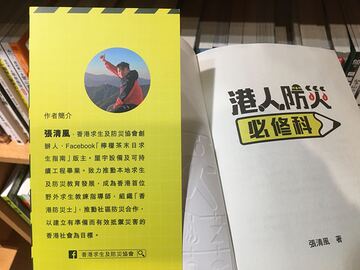
香港社區應急設施地圖 Finding Help in a Crisis: Hong Kong's Community Emergency Facilities Map 此地圖收錄於《港人防災必修科》,作為香港社區應急設施一覽。所有資料僅供參考,詳情請瀏覽所屬政府部門或機構網站。 This map, featured in 《港人防災必修科》, provides a directory of community emergency facilities in Hong Kong. All information is provided for reference purposes only. For the most current and detailed information, please consult the official websites of the respective government departments or organizations. 《港人防災必修科》 作者︰張清風 出版社︰信報出版社 HKEJ Publishing Limited 詳情︰ *註︰臨時庇護中心、避寒及避暑中心或有重疊,詳情請瀏覽民政事務總署網站。 *Note: Temporary shelters, temporary cold shelters, and temporary heat shelters may have overlapping locations. For detailed and up-to-date information, please visit the Home Affairs Department website. 資料來源︰醫院管理局、消防處、民政事務總署、康樂及文化事務署、警務署、空間數據共享平台 Data Sources: Hospital Authority, Fire Services Department, Home Affairs Department, Leisure and Cultural Services Department, Hong Kong Police Force, Common Spatial Data Infrastructure 本網將會不定期更新。 Note: This website is updated as needed. 最後更新日期︰2024年6月30日 Last Updated: 30 June 2024
2025-01-21
chewei 哲瑋
15:47:39
kiang
Hi, 我製作了地圖來蒐集災損照片與位置,只要在地圖空白處點選後就會產生對話框,點選對話框的藍色按鈕即可開啟表單上傳照片,上傳後就會在地圖中呈現
https://tainan.olc.tw/p/earthquake0121/
- Forwarded from #tainan
- 2025-01-21 15:22:46
chewei 哲瑋
15:47:39
Hi, 我製作了地圖來蒐集災損照片與位置,只要在地圖空白處點選後就會產生對話框,點選對話框的藍色按鈕即可開啟表單上傳照片,上傳後就會在地圖中呈現
https://tainan.olc.tw/p/earthquake0121/
- Forwarded from #tainan
- 2025-01-21 15:22:46
2025-01-22
chewei 哲瑋
03:09:40
一則介紹 watch duty app 的貼文
https://www.facebook.com/share/p/1DbvBQoLL6/
此 APP 特點似乎是有針對 災害的動態性 給予疏散指引
• 例如加州野火的擴張蔓延的方位
• 或是基於 車輛壅塞的當下狀況,道路中斷狀況,也會影響如何選擇當下較佳的避難動線
• 聯想到:
◦ 日本 311 核輻射污染,實際上並非同心圓擴散,而是基於當天地區盛行風向而擴散,有一種避難路徑雖然是遠離核電廠,但是其路徑完全籠罩在核污染伴隨盛行風向的傳播軸帶中
◦ 龍捲風的地區移動方位方向,也是家戶判斷要往哪一個方位避難的重要評估,應避免與之平行
https://www.facebook.com/share/p/1DbvBQoLL6/
此 APP 特點似乎是有針對 災害的動態性 給予疏散指引
• 例如加州野火的擴張蔓延的方位
• 或是基於 車輛壅塞的當下狀況,道路中斷狀況,也會影響如何選擇當下較佳的避難動線
• 聯想到:
◦ 日本 311 核輻射污染,實際上並非同心圓擴散,而是基於當天地區盛行風向而擴散,有一種避難路徑雖然是遠離核電廠,但是其路徑完全籠罩在核污染伴隨盛行風向的傳播軸帶中
◦ 龍捲風的地區移動方位方向,也是家戶判斷要往哪一個方位避難的重要評估,應避免與之平行
chewei 哲瑋
03:09:40
一則介紹 watch duty app 的貼文
https://www.facebook.com/share/p/1DbvBQoLL6/
此 APP 特點似乎是有針對 災害範圍的動態性 給予疏散指引
• 例如加州野火的擴張蔓延的方位
• 或是基於 車輛壅塞的當下狀況,道路中斷狀況,也會影響如何選擇當下較佳的避難動線
• 聯想到:
◦ 日本 311 核輻射污染,實際上並非同心圓擴散,而是基於當天地區盛行風向而擴散,有一種避難路徑雖然是遠離核電廠,但是其路徑完全籠罩在核污染伴隨盛行風向的傳播軸帶中
◦ 龍捲風的地區移動方位方向,也是家戶判斷要往哪一個方位避難的重要評估,應避免與之平行
https://www.facebook.com/share/p/1DbvBQoLL6/
此 APP 特點似乎是有針對 災害範圍的動態性 給予疏散指引
• 例如加州野火的擴張蔓延的方位
• 或是基於 車輛壅塞的當下狀況,道路中斷狀況,也會影響如何選擇當下較佳的避難動線
• 聯想到:
◦ 日本 311 核輻射污染,實際上並非同心圓擴散,而是基於當天地區盛行風向而擴散,有一種避難路徑雖然是遠離核電廠,但是其路徑完全籠罩在核污染伴隨盛行風向的傳播軸帶中
◦ 龍捲風的地區移動方位方向,也是家戶判斷要往哪一個方位避難的重要評估,應避免與之平行